


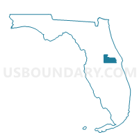
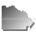
126.1-Voting District, Orange County, Florida
About
Outline

Summary
| Unique Area Identifier | 556953 |
| Name | 126.1-Voting District |
| County | Orange County |
| State | Florida |
| Area (square miles) | 49.69 |
| Land Area (square miles) | 45.49 |
| Water Area (square miles) | 4.20 |
| % of Land Area | 91.55 |
| % of Water Area | 8.45 |
| Latitude of the Internal Point | 28.39528090 |
| Longtitude of the Internal Point | -81.59859980 |
Maps


Graphs
Select a template below for downloading or customizing gragh for 126.1-Voting District, Orange County, Florida


Neighbors
Neighoring Voting District (by Name) Neighboring Voting District on the Map
- 115-Voting District, Orange County, FL
- 126.2-Voting District, Orange County, FL
- 130-Voting District (Westside CDD North), Osceola County, FL
- 131-Voting District (Xentury City CDD), Osceola County, FL
- 140-Voting District, Orange County, FL
- 143-Voting District, Orange County, FL
- 147-Voting District, Orange County, FL
- 149-Voting District, Orange County, FL
- 150-Voting District, Orange County, FL
- 2-Voting District, Osceola County, FL
- 84A-Voting District (Cagan Crossings), Lake County, FL
- 97-Voting District, Osceola County, FL
- NBH6-Voting District (Davenport Highway 27), Polk County, FL
Top 10 Neighboring County Subdivision (by Population) Neighboring County Subdivision on the Map
- Southwest Orange CCD, Orange County, FL (175,234)
- Kissimmee CCD, Osceola County, FL (136,493)
- Haines City CCD, Polk County, FL (119,868)
- Clermont CCD, Lake County, FL (78,848)
Top 10 Neighboring Place (by Population) Neighboring Place on the Map
- Four Corners CDP, FL (26,116)
- Horizon West CDP, FL (14,000)
- Bay Lake city, FL (47)
- Lake Buena Vista city, FL (10)
Top 10 Neighboring Unified School District (by Population) Neighboring Unified School District on the Map
- Orange County School District, FL (1,145,956)
- Polk County School District, FL (602,095)
- Lake County School District, FL (297,052)
- Osceola County School District, FL (268,685)
Top 10 Neighboring State Legislative District Lower Chamber (by Population) Neighboring State Legislative District Lower Chamber on the Map
- State House District 41, FL (252,332)
- State House District 64, FL (165,492)
- State House District 40, FL (149,664)
Top 10 Neighboring State Legislative District Upper Chamber (by Population) Neighboring State Legislative District Upper Chamber on the Map
Top 10 Neighboring 111th Congressional District (by Population) Neighboring 111th Congressional District on the Map
- Congressional District 5, FL (929,533)
- Congressional District 15, FL (813,570)
- Congressional District 8, FL (805,608)
Top 10 Neighboring Census Tract (by Population) Neighboring Census Tract on the Map
- Census Tract 313.11, Lake County, FL (13,462)
- Census Tract 171.05, Orange County, FL (12,286)
- Census Tract 170.17, Orange County, FL (12,179)
- Census Tract 171.03, Orange County, FL (11,629)
- Census Tract 171.07, Orange County, FL (7,794)
- Census Tract 171.08, Orange County, FL (6,397)
- Census Tract 408.02, Osceola County, FL (5,464)
- Census Tract 408.04, Osceola County, FL (3,932)
- Census Tract 124.06, Polk County, FL (3,899)
Top 10 Neighboring 5-Digit ZIP Code Tabulation Area (by Population) Neighboring 5-Digit ZIP Code Tabulation Area on the Map
- 34787, FL (46,083)
- 34746, FL (35,022)
- 34786, FL (28,092)
- 32821, FL (21,423)
- 32836, FL (16,647)
- 34714, FL (14,685)
- 34747, FL (13,692)
- 32830, FL (26)